Louisiana’s Annual ‘Dead Zone’ is Back, and This Time It’s Bigger

Marine biologists and oceanic scientists of all types concur - the so-called "Dead Zone" that seems to appear every year in the Gulf of Mexico just off of the coast of Louisiana is back. As if that wasn't bad enough, it's three times bigger than the one we had to deal with last year!
What is the "Dead Zone"?
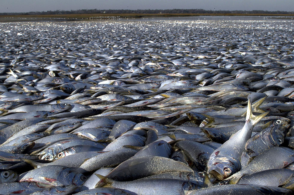
Every year, this phenomenon appears in the warm waters of the Gulf of Mexico. A patch of water in the Gulf loses its oxygen and can no longer support most marine life. Scientists believe that the zone is caused by urban and agricultural runoff that finds its way into the Mississippi River watershed. From there, the chemicals found in this runoff flow into the gulf.
Substances like excess fertilizer and manufacturing byproducts are like an all-you-can-eat buffet to algae living in the open water. This leads to a algae population explosion, and then a mass die off. When the algae die, their decomposition robs the immediate area of oxygen - which fish need to survive. If they can't escape the area in time, they will die - which leads to even more decomposition, taking away more precious oxygen and increasing the area of the zone.

Why is It Bigger?
According to KTBS, the National Oceanic and Atmospheric Administration (NOAA) has discovered that nitrogen and phosphorous runoff data taken from the mighty Mississipi river shows that these levels were well above normal for the three weeks before the agency's yearly weeklong survey started on July 25th. That means we were pumping way more of what algae loves to eat in the water than in years past - thus explaining the reason behind the bigger-than-average dead zone.
How Big is It?
This year, it's a whopping 6,334 square miles - which is almost 3 times as large as 2020's no-swim-zone, which NOAA measured last year at 2,116 square miles. When you take a look at the last 5 years, the dead zone has averaged roughly 5,380 square miles.

Can We Fix It?
Yes we can, but it won't be easy. The key is cutting back on the algae-feeding chemicals that find their way into the waterways. That means telling farmers and manufacturers that they need to back off of the overuse of products they depend on to make a living, like fertilizer. Convincing big industries and/or making life even tougher for the Louisiana farmer isn't the argument anyone wants to use, but we've got to get there somehow. Currently, a federal task force is attempting to do just that in an effort to kill the dead zone by starving it to death. Their goal is to reduce it to just 1,900 square miles or smaller by the year 2035.
LOOK: The most expensive weather and climate disasters in recent decades
Gallery Credit: KATELYN LEBOFF
Read More: Why Does It Only Hail in Summer? And Other Weird Weather Facts
Read More: Most Dangerous Louisiana Creatures
More From K945, The Hit Music Channel


